The royal residence
Dresden has been destroyed a number of times throughout history, such as during the Seven Years’ War. Preserved architectural designs show plans for reconstruction which were only partly realised.
View of Dresden
Coloured drawing from: Atlas royal / dedié à Sa Majesté Auguste III. – Vol. 19: Saxe royale et électorale avec les états circonvoisins. – Dresden 1706/10.
Shelf mark: B7985

The View of Dresden depicts Augustus II the Strong with his entourage watching animal-hunting along the Elbe. In the background is the city, still without Dresden Cathedral but easily recognisable with the old Kreuzkirche, the old Frauenkirche and the Schlossturm tower.
The Atlas Royal was collated at the request and expense of the electors of Saxony from 1706 to 1710 in Amsterdam, which was the centre of cartography and map trading at the time. Its 19 large-format Moroccan-leather volumes contain around 1,400 superbly illuminated printed or drawn sheets (maps, views, designs and portraits).
Royal Palace. Second palace design
Matthäus Daniel Pöppelmann: Royal Palace. Second palace design.
Design and sketch of the font facing the Elbe, with Hausmannsturm, by draughtsman A/B on paper, feather, brush in watercolour. – Circa 1712/13.
Shelf mark: Mscr.Dresd.L.4 (= old inventory no.: Mscr.Dresd.i.8)
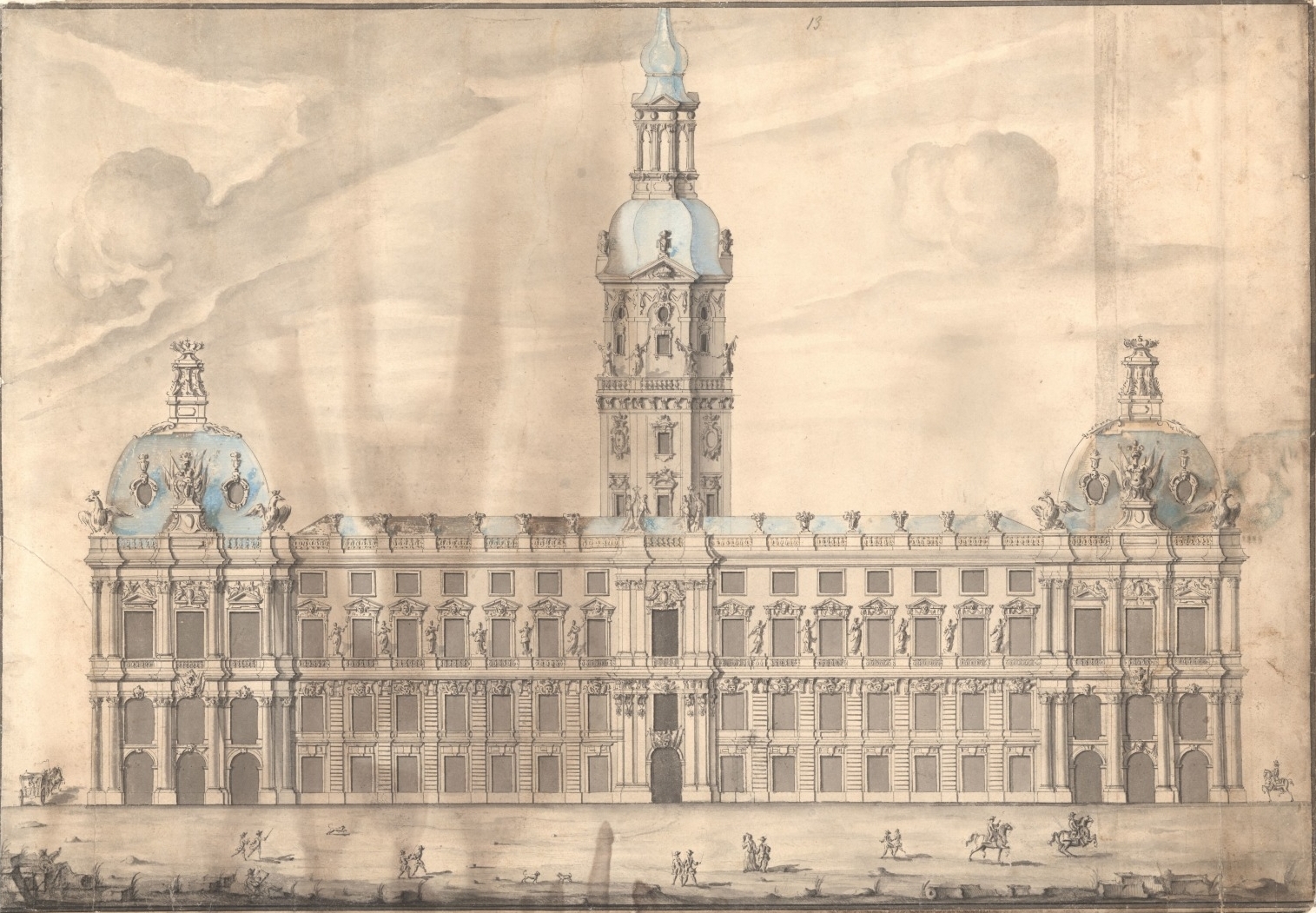
The four-winged Royal Palace was the centre of power of the Saxon electors and kings, and attests to the splendour of the Dresden court. The contemporary design material largely preserved in Dresden’s collections and archives shows that, in addition to the construction work performed at the Zwinger complex from 1711 to 1728, there had always been intentions to modify or even rebuild the Royal Palace, though these were never realised.
Draft design of a gate tower in a gallery of Dresden’s Zwinger
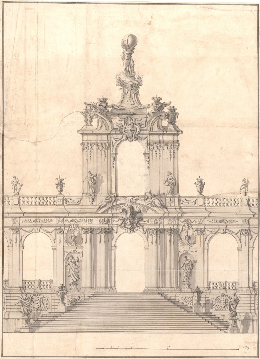
Matthäus Daniel Pöppelmann: Draft design of a gate tower in a gallery of Dresden’s Zwinger
Washed sketch ink on paper. – 1713.
Shelf mark: Msrc.Dresd.L.4 (= old inventory no.: Mscr.Dresd.i.8)
© SLUB / Deutsche Fotothek
The design shows a part of the Zwinger considered to be Pöppelmann’s chief architectural work, and which documents his talent as a Saxon court architect. Not yet intended for carriages, the gate features a staircase. A statue (Hercules instead of Atlas) atop the tower carries a globe of the earth, symbolising Augustus II the Strong as “Hercules Saxonicus”. The sculpture was later affixed to the Wallpavillon.
Zwinger. Wallpavillon design
Matthäus Daniel Pöppelmann: Zwinger. Wallpavillon design.
Sketch by draughtsman B on paper, feather, brush in watercolour. – Circa 1715.
Shelf mark: Mscr.Dresd.L.4 (= old inventory no.: Mscr.Dresd.i.8)

The Zwinger was created in 1709 as an orangery, garden and prestigious ballroom in Dresden. The construction plans were drawn up by architect Matthäus Daniel Pöppelmann (1662–1736), while the sculptural decorations were crafted by sculptor Balthasar Permoser (1651–1732) and his atelier. Original plans of the complex, on display at the SLUB, show the grand scale of the overall design. The Zwinger was the only part to actually be completed in various stages and with multiple design modifications. The sketch of the Wallpavillon displayed here is proof of this; it was ultimately not built with a rectangular base, but rather ingeniously as a curved oval structure.
Project zu Ausfüllung des Grabens bey der Königlichen Residenz Stadt Dresden
François Cuvilliés: Project zu Ausfüllung des Grabens bey der Königlichen Residenz Stadt Dresden.
Coloured drawing, approx. 1 : 2,600. – Munich, circa 1761.
Shelf mark: A19300
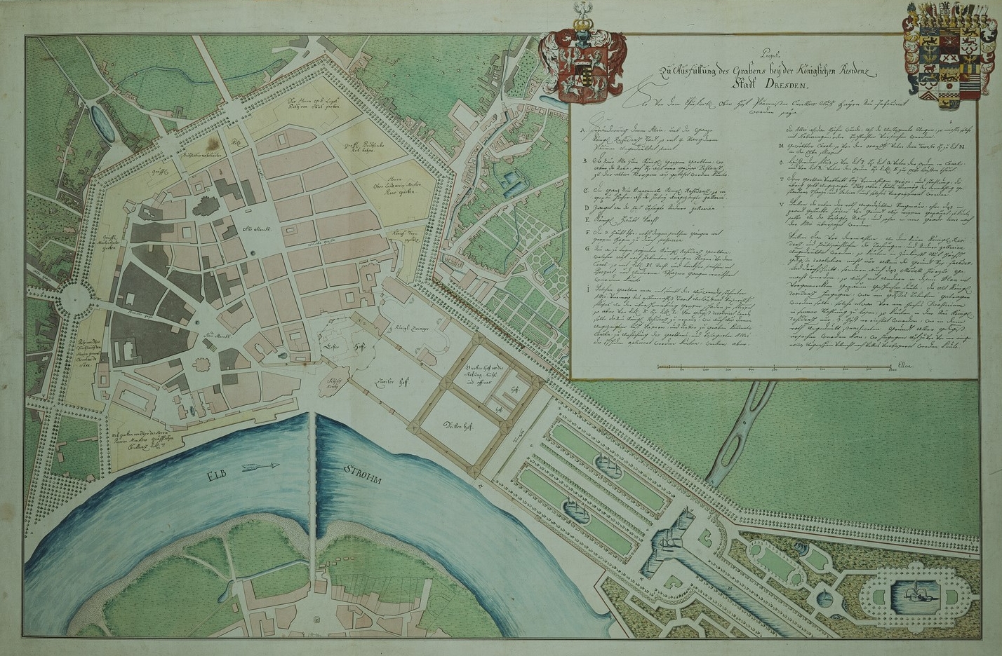
Bavarian chief court architect Francois de Cuvilliés the Elder (1695–1768) created this design as a proposed redevelopment of the Saxon royal city, which had been destroyed during the Seven Years’ War. It was drafted on behalf of Crown Prince Frederick Christian of Saxony, who fled to his brother-in-law, the Elector of Bavaria, following the shelling of Dresden by Frederick II’s troops. This plan shows the destroyed parts of the city highlighted in colour. Instead of the fortifications which had already proven to be of no military worth, the city is surrounded by a broad belt of gardens and open spaces, whose external boundary is formed by a wide boulevard. In his hand drawing, the royal palace, which no longer met the requirements of the time, is replaced by a “Repräsentationshof” or “representative court”.